

Take one computer scientist, one geographer, one anthropologist, two quadcopter drones and eight Android smartphones to the Congo for a month and what do you get? That was the key research question for the latest ExCiteS expedition to Congo-Brazzaville, which got off the ground (quite literally, given the drones) in January 2015. It’s been a busy few weeks and we have a lot to report, so before we get into some of the specifics this blog post gives a bit of an outline of our key activities in the field.
On arrival into Brazzaville we didn’t hang about, and after a night’s rest we took an early flight to Pokola, a logging town which lies on the banks of the Sangha River. There we are working in partnership with the logging company Congolaise Industrielle des Bois (CIB) to introduce Sapelli as a tool for participatory mapping and communication between the company and the forest-dwelling populations who live in their concessions. CIB have the largest and most active social programme out of all of the logging companies operating in Congo, and they are keen to support the development of technology that will make their existing social mapping activities more efficient and effective for everyone involved. To that end, they supported us for two weeks of research within local villages and camps, piloting both ExCiteS’ existing Sapelli software and some ideas for new developments.

Michalis, ExCiteS’ PhD computer scientist, ran a series of human-computer interaction (HCI) experiments in order to determine what kinds of additional feedback would make Sapelli easier for non-literate people to use. Trialling a new version of the software, which plays audio prompts recorded in the local language, each participant was asked to complete a series of mapping tasks either with or without the audio prompts.
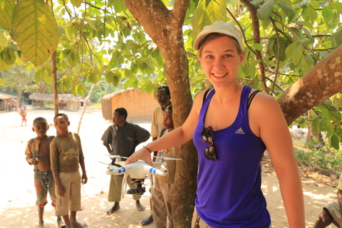
Julia, who is doing her PhD research into the spatial understanding of people who aren’t map-literate, used the aforementioned drones to take aerial photos of the rainforest around each village. After a lot of data processing to connect up the images into a photographic map, she then asked each participant to point out key features – such as their house, the place where the experiment was taking place, and the locations of the mapping tasks carried out in the HCI tests.
Gill, one of ExCiteS two PhD anthropologists, followed the progress of the experiments for the first part of the trip, as one aspect of her research concerns how the ExCiteS software developers design for non-literate communities. She then headed south to conduct a scoping mission with the Wildlife Conservation Society (WCS), who are interested in using Sapelli to support local communities living near the Lefini River Reserve to engage in co-managing wildlife populations.
So, that was just a brief outline of our adventures during the past month, with some nice pictures! Stay tuned for more on drone mapping, HCI and human-wildlife relationships in blog posts to come…

6 Comments