
I’ve never yet seen an elephant in the Congo rainforest, and to be honest it’s a little difficult at times to imagine that animals so large can a) hide themselves so effectively or b) even fit at all in amongst the dense mess of trees and brush and leaves that make up the forest’s ground cover – but I have seen the evidence of the devastation they can cause and as such I’m pretty sure they’re there. It may come as a bit of a surprise to those interested in conservation matters, but protecting elephants is not an uncomplicated issue. National parks, like the one I’ve been working in this past week, have been established in Congo to shelter what are considered to be dwindling animal populations from hunting and poaching activity. Indeed, the ivory of forest elephants is particularly valuable because of its relative density compared to that of savannah elephants, and there are a host of other desirable trophy animals – such as gorillas, chimpanzees and leopards – that live in the same habitats. However, these and other animal populations can wreak havoc on the livelihoods of the communities living around the parks – for a Congolese subsistence farmer, having one’s fields torn up by hungry elephants, gorillas or porcupines can mean many weeks of going hungry, and that’s even before the elephant in question decides it has an itch and that a nearby house might make a convenient scratching post. Hunting and gathering may once have been a fall-back solution in such circumstances, but because the parks are now protected areas, people are not permitted to hunt or gather within their limits. (As you might imagine, the implications for indigenous hunter-gatherers are also complicated – but that’s a matter for a different blog post).

The Congolese Ministry of Water and Forests (Eaux et Forets) is supposed to pay compensation to farmers whose crops or domestic animals have been damaged as a result of their proximity to one of the national parks – however in practice the process of claiming compensation is often time-consuming, bureaucratic and involves filling in a lot of intimidating forms, which is an issue when the large majority of people do not read or write. Enter Sapelli, which ExCiteS is helping to adapt as a tool for communities living in close proximity to the Odzala-Kokoua national park so that they can rapidly communicate information concerning a variety of situations to the park’s management team. In the case of Human-Wildlife Conflict, the park hopes to be able to assist communities to receive compensation from Eaux et Forets as rapidly as possible by collecting data about what kinds of resource have been destroyed, what animals are responsible for the destruction, and when the incidents took place. The data will also help the park’s management to introduce preventative measures for the most common pests – such as flaming torches to keep elephants away.

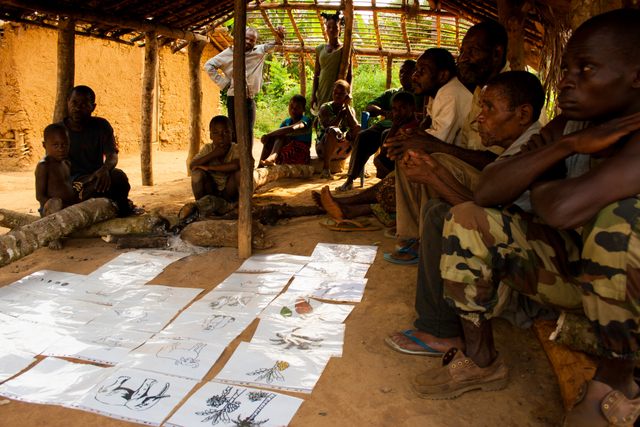
As most of ExCiteS’ work in the Congo Basin so far has focused on resource mapping or recording evidence of illegality, this has meant creating and testing a range of new icons, as well as a decision tree structure that is more questionnaire-like in its construction so that it matches up with the data Eaux et Forets requires. More complicated than any of our previous projects, the application includes simple forms for numerical input (eg. how many trees have been damaged?), a lunar calendar to help estimate dates, and options to photograph and record the names of those people to whom any compensation is due. Initially the app will be used by a team of indigenous animateurs employed by the park, but ultimately it is hoped that a Sapelli-equipped smartphone could be left with some or all of the 71 villages that fall within the remit of the park’s management plan. Either way, developing the application in collaboration with local communities is, as ever, a vital part of the process. Workshops brought up a range of problematic animals that hadn’t been included in the first prototype – including porcupines, cane rats, civets and snakes. Images of the moon’s major phases were rapidly recognised by each group we worked with; combined with the date any observation is made, this means we have a hopefully reliable means of calculating the date of an incident that has happened in the past in a context where most people don’t use a numerical calendrical system. The next phase of the project will begin in October, when a larger ExCiteS team will return to assist in training the indigenous animateurs, and to set up an improved version of the Sapelli transmission system. We also hope this will be a good opportunity to conduct some rigorous usability experiments and test out some ideas for visualising cartographic data for non-literate users. Watch this space…

1 Comment