
 As in last year, twenty mobile app developers gathered for the Space App Camp in European’s Space Agency (ESA) main campus at Noordwijk, Netherlands, to come up with creative ideas. The participants in this years’ app camp were grouped into teams of four and their goal was to integrate Earth observation data gathered by the Copernicus program into their everyday life applications.

We, Julia and Michalis from ExCiteS, took part as a team of two and were teamed up with Dimitrios and George from Centre for Research and Technology Hellas (CERTH) in Greece. Dimitrios Ververidis works as postdoctoral researcher, while George Liaros works as research assistant in CERTH. Both of them conduct research on eGoverment, Smartdevices and Augmented Reality amongst other things and are responsible for the development of Live+Gov.
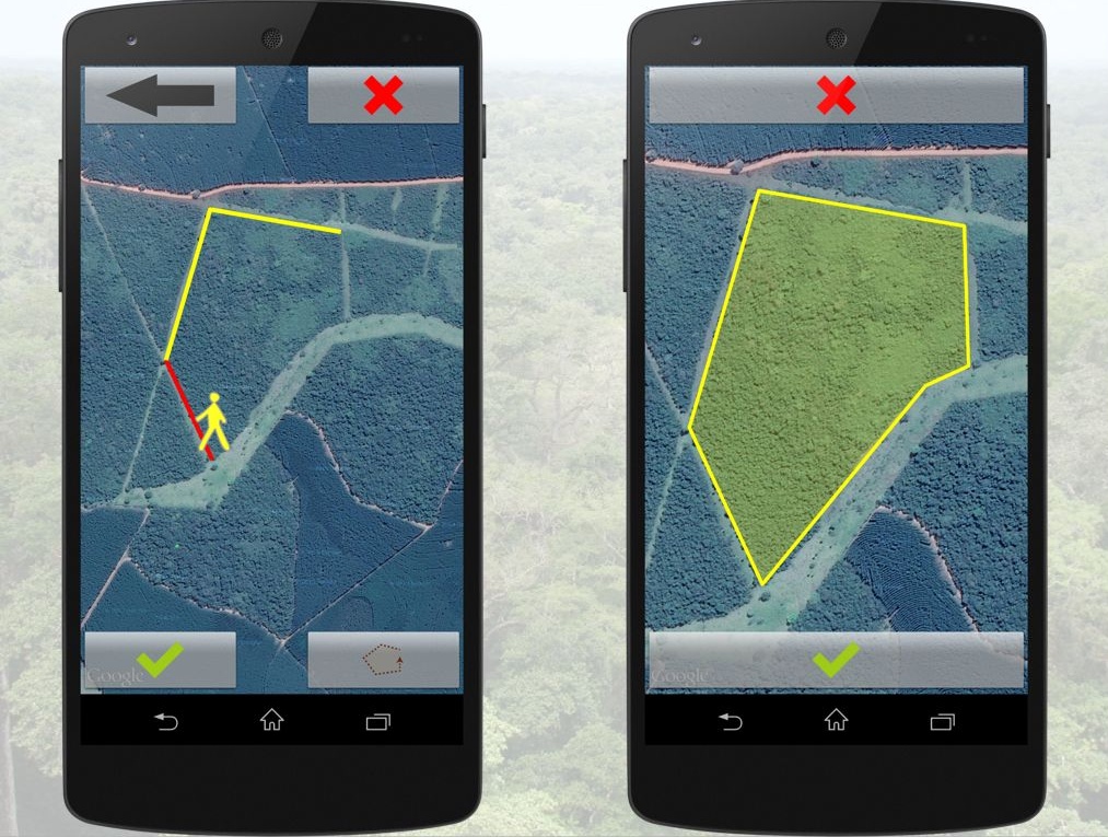
Our objective of the week was to develop a mobile app that incorporates Copernicus satellite data and contributes to environmental protection. Since we have planned to include high-resolution, satellite data in our Sapelli app anyway, it seemed like a perfect opportunity to put our ideas into practice. Purely icon-based user interfaces, like those we have tested during our field trip in Republic of Congo have the advantage that they are easy to learn even for non-literate users. However, it remains a major challenge to communicate the higher concept of participatory mapping to people who have no prior experience with digital technology or maps. Therefore the idea was to prompt a true-colour, high-resolution satellite image overlaid with their observation before confirming their choice, saving and sending it to a central database.
Providing feedback in a confirmation screen like this, allows non-literate users to better understand the abstract process of participatory mapping, in-situ verify their results and as a side effect improve their spatial understanding of their land and their map reading skills. Furthermore, a common request we have from NGOs is to include boundary mapping to capture community territories in addition to point locations. Given this feature will be deployed in situations where people would walk for hours or even days in order to capture the desired extent, visual feedback is essential to ensure effective and successful use.
The experience was interesting and rewarding, as we had the chance to have a look into ESA’s data and experiment with a potential, future integration with our tools. The easy part of developing a functional prototype during the app camp is done, now we have to examine its efficiency and most importantly check if it serves its purpose of providing comprehensible feedback to the user by testing it with our local communities. However, conducting usability experiments outside the controlled environment of a lab, has great challenges as he discussed here. So, if anyone has more experience on conducting usability testing under these circumstances, with local communities and wants to collaborate with us to test our approach, please contact us.
