by Simon Hoyte
The ambition of Extreme Citizen Science and our mapping tool Sapelli has always been to co-develop projects with Indigenous Peoples, local communities, and locally based organisations which reach a point where we, as implementers from London, become redundant.
Often in the projects I have co-designed in Cameroon alongside hunter-gatherers, despite this intention of making myself redundant, there remains certain aspects which depend on my input and problem solving. These are most often the technical aspects such as if the communities want to change their Sapelli projects, the Sapelli app goes heywire, or the phone starts to misbehave. As much as I try to include time during my fieldtrips to train local facilitators in how to tackle all of these potential problems, I can never cover everything and up until now much of the Sapelli system was complicated to manage.
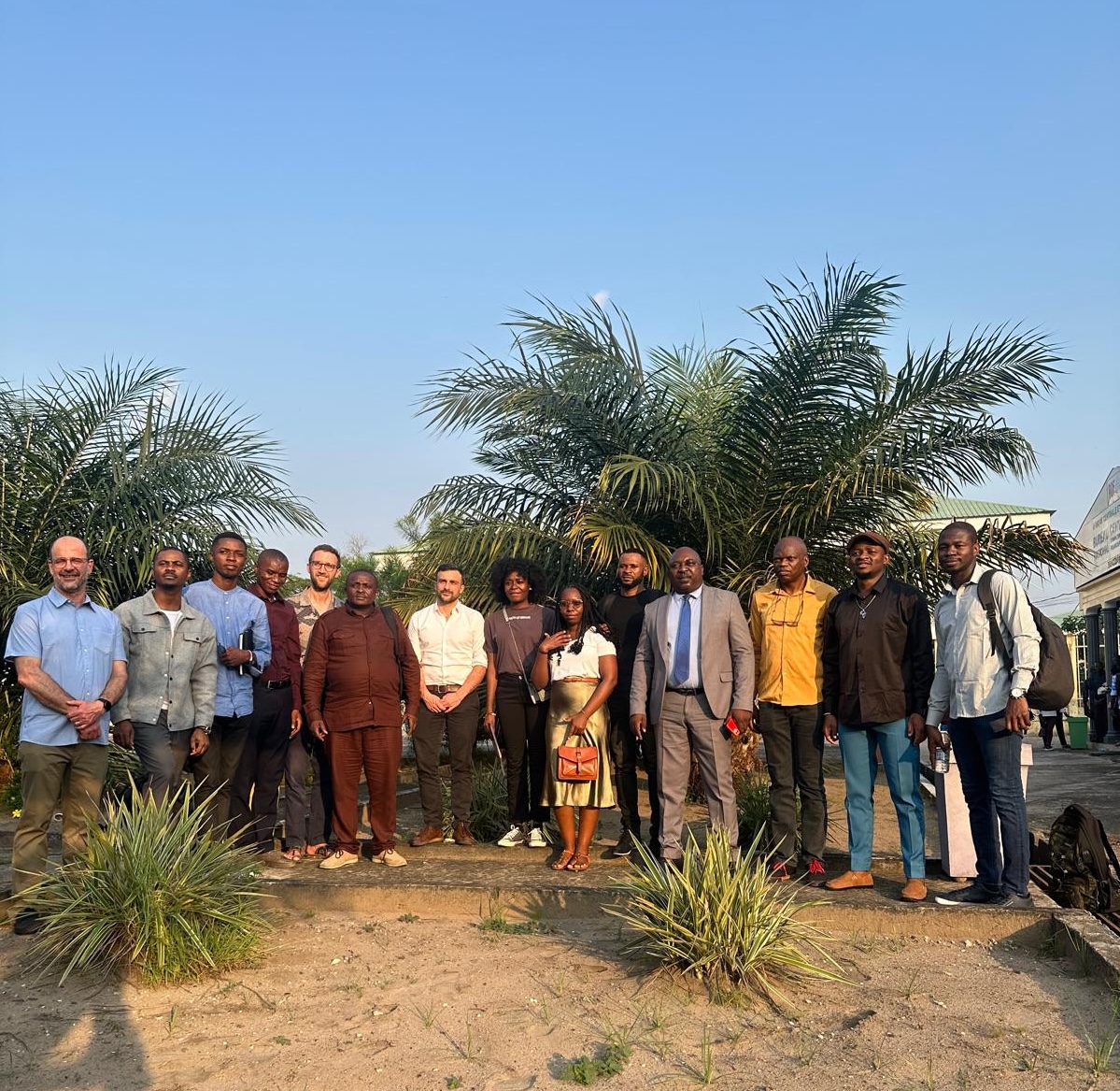
But recently we reached what feels like a milestone. A dedicated 2-day training session in Brazzaville, Republic of Congo, with eight Masters and PhD students and three professors from universities across Central Africa – Cameroon, Republic of Congo, and the Democratic Republic of Congo. This training was explicitly to enable this group of remarkable individuals to be able to create and manage Sapelli projects using the Extreme Citizen Science methodology.
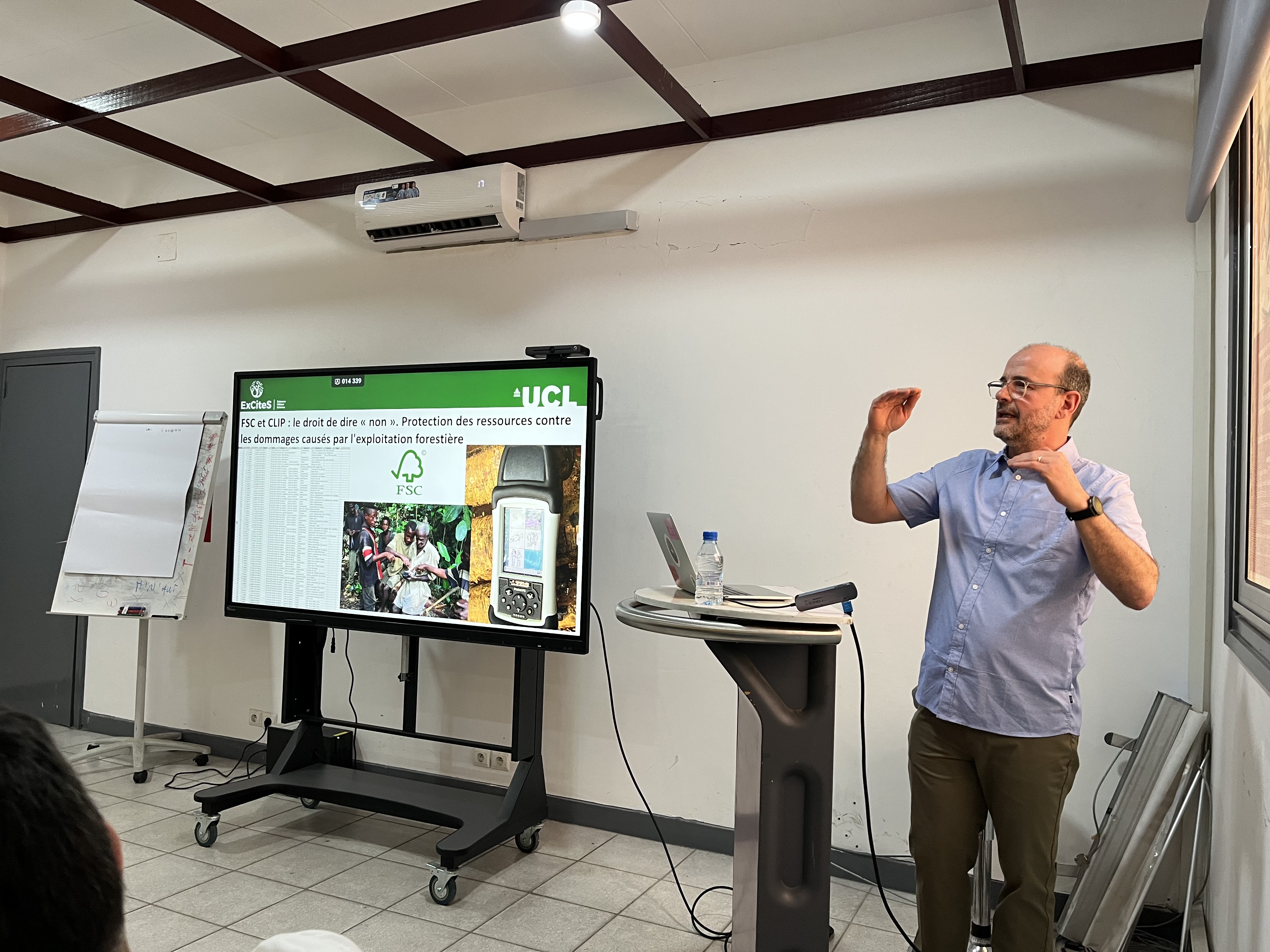
With an explicit focus on the three hallmarks of Sapelli and Extreme Citizen Science – icon-based design, Free, Prior, and Informed Consent (FPIC, or CLIP in French), and community protocols – Fabien Moustard, Jerome Lewis and I shared our and our colleagues’ experiences from co-creating and managing projects from across the world: Cameroon, Congo, Central African Republic, Ghana, Nigeria, Kenya, Ethiopia, Zambia, Namibia, Morocco, Brazil, India, Cambodia and others. We needed to emphasise both what worked as well as what didn’t work (much to say on both sides!).
From this, the students and professors shared with us potential projects that they would love to carry out with Sapelli. The diversity of these was wonderful – from recording the activities of a matriarchial society in western DRC to human-wildlife conflict and ecological dimensions of totem animals in Cameroon. Whilst none of the participants were from hunter-gatherer communities, the training helps them to excel in positions to support these communities, especially in capacity building and forming associations and organisations which, I can say for Cameroon, is urgently needed.
FPIC – the process of informing communities about the project, explaining the potential benefits and potential risks – was perhaps the most discussed topic. It is a long-winded procedure and must be done in the right way, and some of the questions asked by the students showed fantastic critical thinking: How long should FPIC take? The communities won’t sit around for hours, how do we ensure a proper comprehensive process? At what stage is FPIC considered sufficient? If it’s only partial consent does that count?
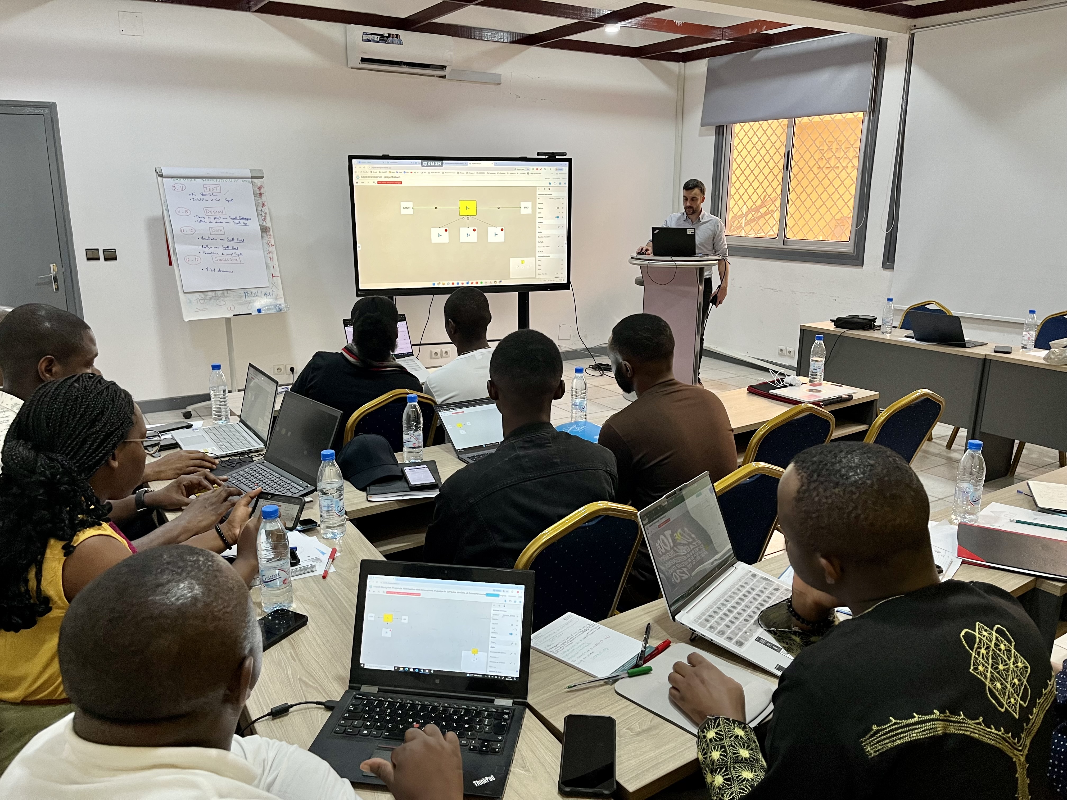
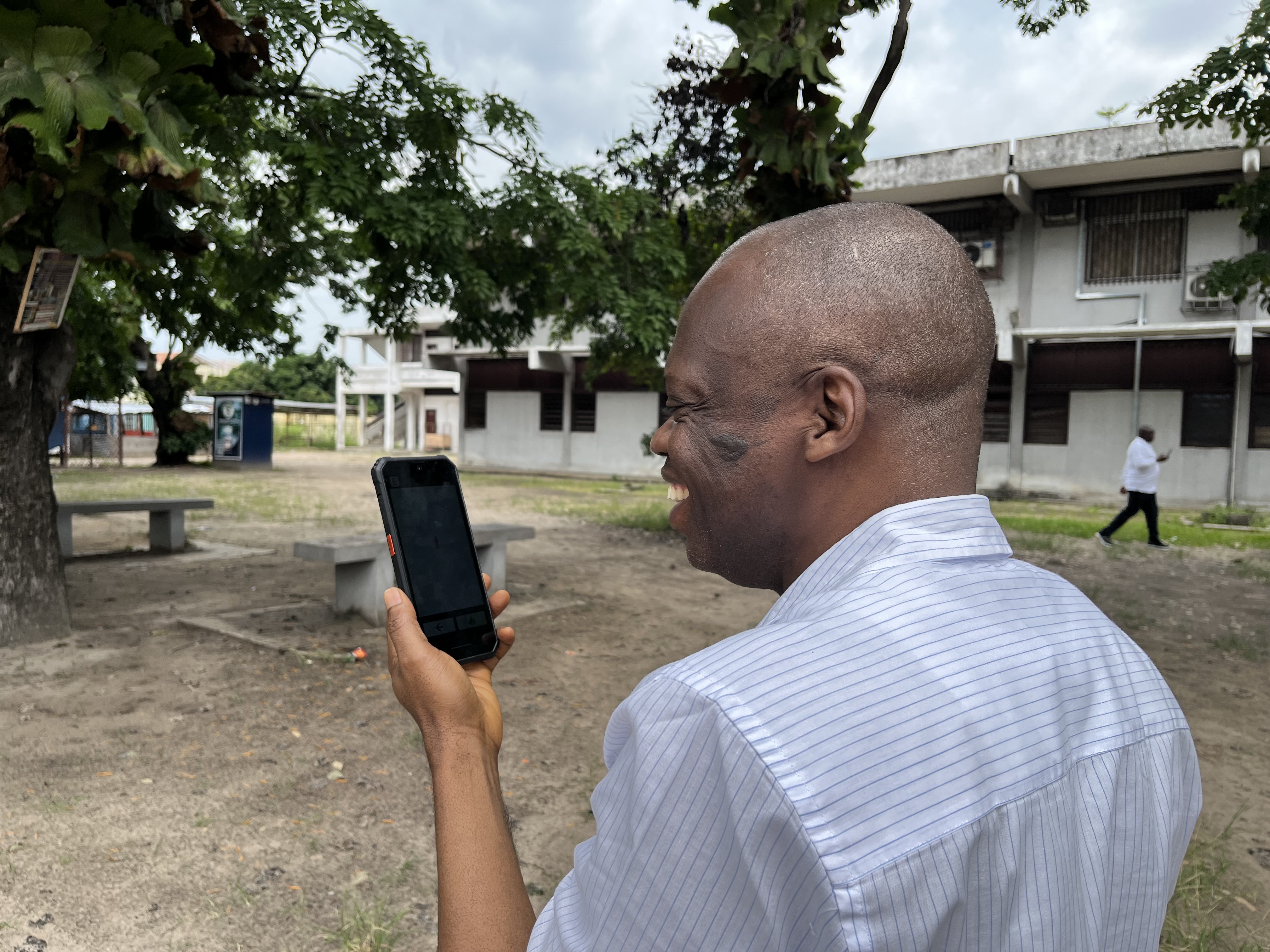
Having worked with Sapelli for almost a decade, it was really fulfilling for me to see these students, and the professors, take to the technology so warmly and instantly see its use and potential. Having explored the 8-steps of Sapelli (available in English here and French here), each participant drafted out a potential Sapelli project for their research using a Project Design handout (available in English here and French here). From this, they started drawing icons which could make up the pictures in their Sapelli app. Once each student and professor had a set of icons they were happy with, we helped them to make their Sapelli project using our online tool Sapelli Designer. Once each had a project saved, they installed it onto the test phones and took some sample records outside the room, photographing trees and recording audio, each with a GPS point. Now that they had records we demonstrated how to sync these with the database – Sapelli Portal – and how to visualise the data points and download the data.
I think it’s fair to say everyone had fun, despite the overhaul of information!
Both these students and the professors are part of the Congo Basin Science Initiative (CBSI), aiming to create a ‘large network of scientists, led by those from the region, seeking to increase investment to train a new generation of scientists and transform our understanding of the world’s second largest rainforest‘.
The initiative is made up of six observatories: Climate, Vegetation, Hydrology, Biodiversity, Land Cover and Socio-Ecology.
The first Congo Basin Science Initiative conference was held in Brazzaville just after our training so we all attended it together. Some incredible stats about the Congo Basin were thrown at us by keynote speakers such as Simon Lewis (UCL and Leeds University) and Raphael Tshimanga (Kinshasa University).
And the Congo Basin rainforest, though you may not have heard much at all about it, is exceptional. Although it is smaller than the Amazon rainforest, it is the largest carbon sink of any forest in the world and has 40% more biomass than the Amazon. It also has the largest tropical peatland in the world which, if deforested and left to dry up, would contribute the same amount of carbon to the atmosphere as three years of global emissions.
Perhaps most remarkably, particularly if you’re an anthropologist, the Congo Basin hosts the largest number of hunter-gatherers left in the world (perhaps up to one million). Spread from Cameroon to Uganda, these hunter-gatherers are made up of around 15 distinct groups with diverse languages and unique spiritual and ritual culture.
Despite it’s clear importance locally and globally, the Congo Basin rainforests have been neglected: there’s not enough data, for example, to even predict whether the forests will get dryer or wetter with climate change. What is likely, however, is that the Wet Bulb Temperature (measure of ambient heat and humidity) will exceed 32 degrees centigrade in many locations across the region in the future, a temperature-humidity level which is regarded as the limit of human survivability. A massive drive for more research is urgent and it’s local people that will lead the way.
The 2.5 billion dollars promised for the Congo Basin at the Belem Biodiversity COP (the ‘Congo Pact’) is a potentially massive opportunity, however many concerns have be raised as to who this money will be channeled to – will it be the same big NGOs, consultants in Europe/US, or local organisations?
The Socio-Ecological Observatory is led by Professor Jerome Lewis (co-founder of the Extreme Citizen Science group and Sapelli) and in collaboration with Professor Guy Moussavou (Brazzaville, Republic of Congo), Professor Alphonse Maindo (Kisangani, DRC), and Professor Michel Bisa (Kinshasa, DRC).
The observatory held a nice session where several of the students presented their research plans. Prof Moussavou stressed the importance of epistemic diversity (the diversity of knowledges) and asserted that with no epistemic justice there will be no adequate solutions to the threats to the Congo Basin. He said:
“Indigenous knowledge is not a belief, it is a science.”
I couldn’t agree more.
Prof Bisa highlighted the profound importance of local wellbeing and livelihoods in tackling any environmental problems:
“They say the problem is destruction by local people but this is wrong. The real problem is poverty. Is it is measures to address this that can enable local heritage to flourish”
And Prof Maindo advocated strongly for bottom-up approaches using participatory science by and with local communities.
Many of the other sessions described important research plans, but I recognised a large, Indigenous and local community-shaped gap in them. Our community mapping app Sapelli could certainly add a huge amount of value and opportunity to these other projects.
With such a great team of Professors, Masters and PhD students so keen on bottom-up methods and Sapelli mapping, I feel that a exciting shift towards prioritising Indigenous and local community knowledge is well underway…